American Tribes
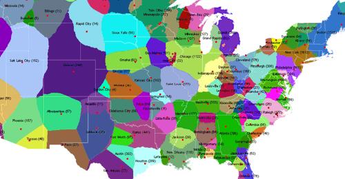
a collaboratively generated geographical map of the US that visualizes how the country is organized culturally, as opposed to its traditional political boundaries. the map attempts to show how the country is divided into ‘spheres of influence’ between different cities at the national, regional & local levels.
You can place a few votes with CommonCensus regarding what city has the most economic/cultural/etc influence on you and where you live, and contribute to the composition of the map. They’re saying its a little rougher than they’d like right now, so more votes = more resolution. Removing the context of state lines and city limits provides a more accurate representation of how we view our country and identify with other people. I’ve always thought the goal of visiting all 50 states was a little overrated, but visiting all these tribes would make a lot more sense, and be a more significant accomplishment to boot.
LINK(via information aesthetics < Wired)
Update: CommonCensus has been getting some good attention lately, and they’ve updated the map to reflect all the new votes – now around 16,000. You can still view the 8,000 and 4,000 vote maps on their website, as well as another project they’re working on that applies the same idea to sports. The next update will be published at 32,000 votes, and so on – the resolution and accuracy improves as they obtain more data. Contributing takes only 12 clicks.